|
The River Allier is a complex hydrosystem variable in space and time with fluvial dynamics as its primary driving force. Maltreated for the last 50 years by simplistic, uncoordinated management linked in part to unsuitable use, the Allier is at present suffering considerable dysfunctions. Fortunately, its fluvial dynamics still endows it with the capacities needed for restoration, but only provided that its management evolves to become more consistent, comprehensive and coordinated.
|
The need to preserve the Allier’s fluvial dynamics and to abstain from irreversible developments was highlighted in the 1980 by active local associations (the publication Rivière Allier, a special issue of Nature Vivante, SEPNMC-FRANE, 1982), but the awakening of general awareness is much more recent (since about 1995) and is still far from unanimous.
While actions such as those of the Loire Nature programme enable these goals to be attained on occasions and exemplary, demonstrable measures to be carried out, there is still much to be done to extend them to the whole course of the Allier. The Schéma Directeur d'Aménagement et de Gestion des Eaux (SDAGE – water development and management master plan) run by the Agence de l'Eau Loire-Bretagne (Loire-Brittany water board) validates the goals, but local application (SAGEs) is not yet complete.
A MANAGEMENT CONCEPT FOR THE ALLUVIAL PLAIN: LIBERTY ZONES
The liberty zone, or bed mobility zone, is the zone to be conserved to allow the watercourse to retain its potential to meander as well as to optimize the functioning of ecosystems.
In practical terms, it designates the area that is potentially erodable while respecting human constraints of community interest. Its limits are therefore defined in consideration of geomorphological, ecological and socio-economic factors.
No obstacles to the wanderings of the river should be sited within this area. It will be necessary to compensate owners of land subject to erosion. Work can be undertaken to restore the fluvial dynamics, such as the removal of rockfill. Drinking water abstraction units may in some cases employ small-scale bores that can be moved as a function of erosion.
A liberty zone also encourages rational land-use, such as extensive grazing, compatible with the risk of erosion, conserves the water reserve and has ecological benefits.
On the Allier, the liberty zone has been defined from Brioude to downstream of Moulins (DIREN Auvergne, EPTEAU, 1998). it varies in width from a few hundred metres to 2 km in the most dynamic sectors, and has an overall area of nearly 15,000 ha. The task now is to set up the systems and resources necessary for its implementation.
France’s July 2003 law on natural and technological risks mentions a liberty zone for watercourses for the first time in a body of regulations.

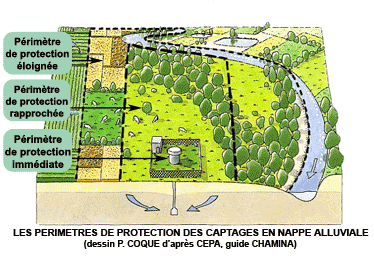
STRENGTHENED CONSERVATION MEASURES WITHIN THE PROTECTION BOUNDARIES OF ABSTRACTION UNITS
Imposed by law, the protected-area boundaries organize the use of land around drinking-water abstraction points in order to limit pollution risks.
Immediate protection zones, a few tens of metres around each well, must be acquired, enclosed and under grass.
In the close protection boundaries that define the catchment zone, varying from a few hectares to some hundreds of hectares, use is regulated by the prohibition of polluting activities.
Distant protection boundaries, being the zone feeding the catchment, prohibit activities and developments posing a high risk of pollution. This last type of boundary cannot be applied in an exact sense to abstraction from the alluvial water table of the Allier, as the actual zone feeding it is the entire catchment upstream of the abstraction. The SAGE (water resource management master plan) is then the more suitable instrument.
Mandatory though they are, protection boundaries are not yet applied to all the abstraction points in the Allier Valley. Furthermore, in addition to regulatory measures, proactive management is needed on protection boundaries to improve protection of the resource by management tailored to habitats, and to encourage good practices.
Diagram of organization of the liberty zone (CEPA)
|
")
")


 Measures
Copyright © 2026 RIVIERE ALLIER. All Rights Reserved.
AtoutEvents Communication Mentions légales
Measures
Copyright © 2026 RIVIERE ALLIER. All Rights Reserved.
AtoutEvents Communication Mentions légales