")
")


 |
|
|
ACROSS ITS CATCHMENT AREA |
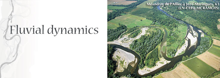
FLUVIAL DYNAMICS
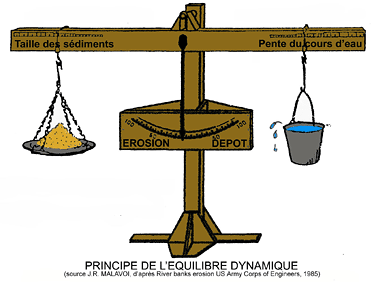
Energy to be dissipated
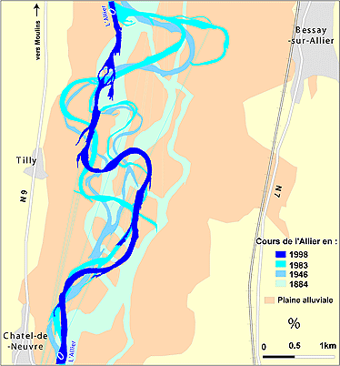
THE ALLIER, AN UNTAMED RIVER The traces left by former watercourses bear witness to its extremely intensive dynamics. The surface area eroded by the Allier along 220 km of its course across the plain has been estimated at 420 ha over 12 years, equivalent to a mean erosion rate of more than 1,500 m²/yr/km over its length (EPTEAU, 1998). This is three times the erosion rate of the Loire measured between Villerest and Nevers! Overall, the Allier presents a sinuous but non-meandering style, since it windings are not very marked. This style of the Allier, which formerly displayed multiple braided channels, will probably evolve further. DYNAMICS WITH MANY BENEFITS Evolution du tracé de l'Allier à Châtel-de-Neuvre entre 1884 et 1998 (CEPA)
|
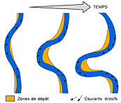
THE MEANDER: SITE OF EROSION AND DEPOSITION
On the alluvial plain, the watercourse dissipates its energy by reducing its gradient and lengthening its course by forming meanders. Currents of helical form tear material from the concave bank and deposit it on the opposite bank. In this way, the channel migrates towards the concave bank and downstream, forming a meander.
When the meander becomes too marked, the river may either cut straight across it, or shorten it gradually. The abandoned channel becomes a backwater.
Schéma formation méandre
Partenaires financiers du programme Loire nature en Auvergne


You are here: Accueil  Fluvial dyn.
Copyright © 2026 RIVIERE ALLIER. All Rights Reserved.
AtoutEvents Communication Mentions légales
Fluvial dyn.
Copyright © 2026 RIVIERE ALLIER. All Rights Reserved.
AtoutEvents Communication Mentions légales