|
Like its sister the Loire, of which it is the main tributary, the Allier is often considered "one of Europe's last great untamed rivers". Indeed, with its extremely varied course, 425 kilometres long, that has suffered relatively little human intervention compared to other large watercourses, the Allier has highly active fluvial dynamics, resulting in continuous shifting of its bed and great ecological diversity.
On this web site, the participants in the Loire Nature programme in Auvergne, the Conservatoire des Espaces et Paysages d'Auvergne (Auvergne region and landscape conservation), the Ligue pour la Protection des Oiseaux Auvergne (Auvergne league for the protection of birds) and the Conservatoire des Sites de l'Allier (Allier site conservation) will introduce you to their magnificent river.
|
THE RIVER ALLIER AND ITS CATCHMENT AREA
From source to confluence, the River Allier displays a great variety of contrasting landscapes due to the geological diversity of the Massif Central. While its southern reaches are shaped by the forms of metamorphic and volcanic relief, further north it imposes its own dynamics on the sedimentary basins.
THE UPPER ALLIER
The Allier rises in Lozère, at the foot of the Moure de la Gardille, at an altitude of 1,485 metres. With the passage of time, in Haute-Loire, it has carved out a very steep-sided valley between the Dèves basalt plateau to the east and the Margeride granite massif to the west, the Allier Gorges. Here the river flows as a torrent, with alternate flat stretches and rapids, through a landscape of rocks, heathland and forest.
In the valley below Langeac comes a succession of steep-banked meanders and zones of broader flow.
THE VALLEY OF THE BRIVADOIS ALLIER
As it traverses its first rift basin, between Vieille-Brioude and Issoire, the Allier deposits a proportion of the material eroded further upstream and winds across the plain, where cultivated areas alternate with mixed pastureland and forest.
THE TRANSITION ZONE FROM ISSOIRE TO PONT-DU-CHATEAU
The river is hemmed in again between steep banks for 17 kilometres when it reaches the granite horst of Saint-Yvoine. Then the Allier gradually flows into the rift basin of the Grande Limagne with a limited flood plain, significant fall and a very winding course.
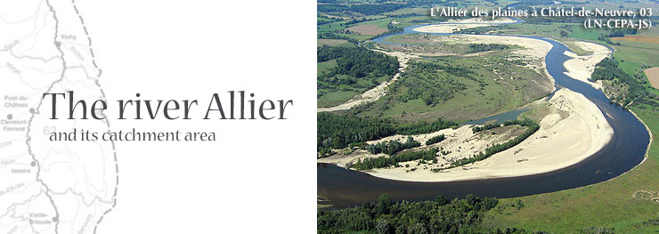
THE ALLIER ON THE PLAINS
From Pont-du-Château onwards, the Allier’s alluvial plain becomes wide with a very slight fall. The river then follows a winding course through a broad flood plain. The corridor formed by the river and its adjacent natural habitats form a narrow passage under pressure from towns and the Limagne’s arable farms.
425 kilometres from its source and at an altitude of 167 metres, after draining a catchment area of 14,310 square kilometres, the Allier flows into the Loire at Bec d'Allier (a "bec", meaning "bill", is the spit of land at confluences in the Loire Basin).
|
")
")